
Introducing Tanzania; its History, Geography, and Cultures
Introduction
This first activity will provide an overview of the geography and cultures of Tanzania. After this activity you should be able to identify Tanzania’s major geographical features and discuss how these impact the country’s people and economy. You should also be able to discuss Tanzania’s cultural and religious diversity.
Jamhuri ya Muungano wa Tanzania (which is Kiswahili for the United Republic of Tanzania) was formed in 1964 by a union of the country of Tanganyika and the islands of Zanzibar and Pemba. These two areas had both previously been colonies of Britain and then attained their independence separately; Tanganyika in 1961 and the islands in 1963. The name Tanzania is a combination of Tanganyika and Zanzibar. The country of Tanganyika was named after Lake Tanganyika that forms a large part of its western border. The name Zanzibar probably comes from a Persian word meaning “coast of the blacks,” however the Swahili name for the island is Unguja.
Do you think that Tanzania is properly named? Why or why not?
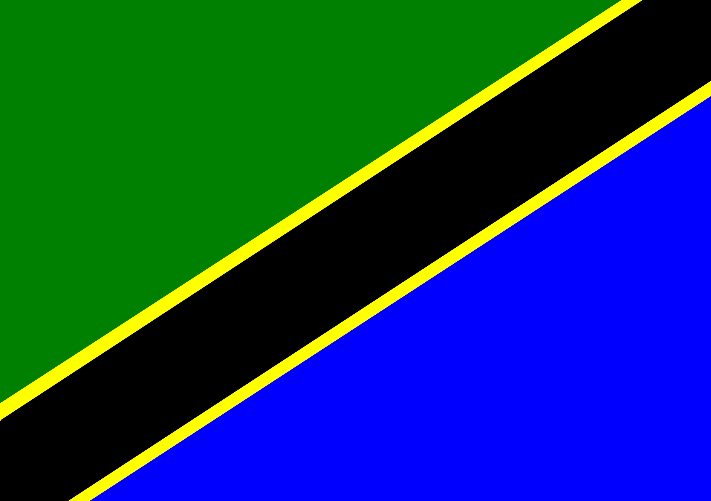
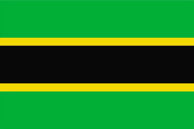
The flag of Tanzania combines the flags of Zanzibar and Tanganyika
Like the name “Tanzania,” the Tanzanian flag combines the flags of Tanganyika and Zanzibar, which you see below. The green of the flag represents the country’s fertile land, and the blue represents the Tanzania’s rivers, lakes, and the Indian Ocean. The black band represents the people of Tanzania and the two gold stripes represent its rich mineral resources.

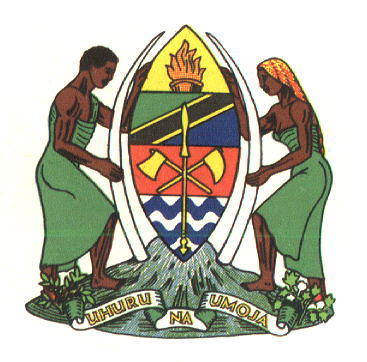
On the coat of arms you can see a warrior’s shield on top of Mt. Kilimanjaro, the tallest mountain on the African continent. Beneath the mountain is the motto of Tanzania, “Uhuru na Umoja” which is Kiswahili for “Freedom and Unity.” These are two concepts that are very important to Tanzanians and are echoed throughout its history. Freedom here refers to freedom from former colonial rulers and unity stands for the unity of Tanganyika and Zanzibar, as well as the unity of all of the various ethnic groups that comprise the region to form the nation of Tanzania.
Geography
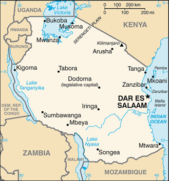
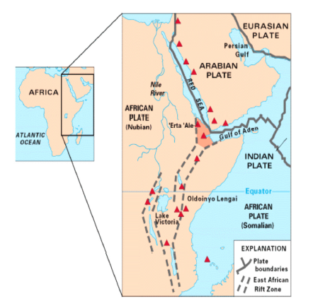
Tanzania lies in East Africa on the Indian Ocean coast. The mainland is bordered by Kenya to the northeast, Uganda, Burundi and Rwanda to the north and northwest, the Democratic Republic of the Congo to the West, Zambia and Malawi to the southwest and Mozambique to the South. Large lakes (Lake Victoria, Lake Tanganyika, and Lake Malawi) are an important geographical feature of the country. Running right through the middle of the country is the Great Rift Valley. Since this geological formation has had a large impact on the rest of Tanzania’s topography and climate, it is a good starting point for discussing Tanzania’s geography.
The Great Rift Valley
The Great Rift Valley is a geological feature that runs approximately 5,400 miles from the country of Syria (western Asia) in the north to the country of Mozambique (just south of Tanzania).
The valley was formed by the separation of the African and Arabian tectonic plates, a process that began around 35 million years ago. The Eastern fork of the valley runs right through the middle of Tanzania’s mainland and has contributed to the formation of Tanzania’s other natural features such as its deep lakes and high mountains.


What kinds of general climates and landscapes would you expect to find in Tanzania? Use the map, pictures, and descriptions you have seen so far to develop an educated guess.
Climate & Rainfall
The geographical regions of Tanzania’s mainland have natural divisions formed by the Great Rift Valley. To the west of the valley, a plateau stretches toward Lake Tanganyika. This region is composed of woodland savannah and does not receive more than 1,000 mm of rain a year. Northwest of the valley toward the western shore of Lake Victoria, the land is higher in altitude and has thicker vegetation due to increased amounts of annual rainfall. To the south, toward Lake Nyasa, lie the Southern Highlands that consist of mountains and a high plateau. East of the Rift Valley, the land gently slopes toward Indian Ocean.


How many inches of rain is the 1000 mm mentioned above? (1in = 25.4mm)
As you can see from the map above, Tanzania lies very close to the equator that runs just north of the country through Uganda and Kenya. This means that fluctuations in temperature from season to season are not extreme; however there is some variation from region to region within the country. You might think that it would be consistently hot at the equator, but in some parts of the country there is the risk of frost at certain times of the year. Altitude is the reason for this. Even though it is warm most of the time in most parts of the country, the higher altitudes of some areas have the effect of cooling the climate down. Think of Mount Kilimanjaro (which we will discuss later). Even though it is right next to the equator, the mountain has snow and glaciers on its summit because of its high elevation.

Many people in Tanzania are farmers so they rely on rainfall for their livelihoods. In general, there are two rainy seasons throughout the country—the long rains from mid March through May and the short rains during November, December, and January. Unfortunately, the East African region as a whole has in the past decade experienced great variability in rainfall as a result of global warming. As a consequence of climate change agricultural production in Tanzania has declined. The coolest months are from June to October, and the warmest are December to March. Along the coast and on Zanzibar and Pemba, the climate is considered tropical (warm year-round with relatively high humidity). In the woodland savannah of the west there is much lower humidity and the average temperature is lower than the coast because of the elevation of this highland plateau region. The northwest region is also located at a higher altitude, but receives more rainfall than the west. In the south, the temperature is also moderate due to the fact that this is a mountainous region. The central region is semi-arid meaning that it gets less rainfall and therefore is much drier.

Now that you have learned about Tanzania’s varied climates, hypothesize about how these climates affect farming.
How does the climate influence tourism? When would you expect to have the most tourists from other parts of the world? Why?
Lakes, Rivers, Oceans
The Great Lakes (of East Africa)
Lake Victoria (Ukerewe)

Lake Victoria is located in the northern region of Tanzania and it actually forms part of the border of three countries—Tanzania, Kenya, and Uganda. It was named for England’s Queen Victoria and is the largest lake in Africa measuring approximately 26,500 square miles. The peoples in the area called the lake Ukerewe prior to the arrival of European colonialism. It is also the second largest lake in the world in terms of surface area—second to Lake Superior which is 45,000 square miles. Lake Victoria is a freshwater lake and is the source for the longest branch of the Nile River, the White Nile. Fishing in this lake is important not only to the people who live on its shores, but also to Tanzania’s national economy. In the 1950’s a new type of fish called the Nile perch was introduced to the lake in order to boost its fishing output. This, however, had a devastating impact on the lake’s ecosystem. The Nile perch fed on the local species, some to the point of extinction. In fact, the perch have substantially changed the whole ecosystem of the lake to the extent that few other species of fish can survive there. Moreover, the perch are now being over-fished, which is threatening the fishing economy of this region of Tanzania and even the national economy.
If you were in charge of fisheries and wildlife in Tanzania, would you address the current Nile perch issue? If yes, what would you propose and why? If you decide to say “no,” and ignore the situation, what would be your reasoning?


Lake Tanganyika

The mainland part of Tanzania (Tanganyika) was named for this lake that forms much of the western border of the country. The lake also shares a border with Burundi, the Democratic Republic of the Congo and a small part of Zambia. It is the second largest lake in the world by volume, the second deepest, and the longest. Tanganyika is one of a chain of lakes that lie in the bottom of the western branch of the Great Rift Valley. Kigoma and Rukwa are two of Tanzania’s larger cities that lie on the shores of Tanganyika, and these are centers of the fishing industry as well as ports which serve as a main hub for inland transport of goods to other areas along the lake’s shores. Because of the rich soil and mineral deposits around the lake, there is also a significant amount of mining and agriculture in this region.
Lake Malawi
Lake Malawi is also called Lake Nyasa, a name that comes from the Yao language of northern Malawi and Mozambique. This lake lies along the southwestern border of Tanzania and also borders Malawi and Mozambique. Like Lake Tanganyika, Lake Malawi lies in the bottom of the western Great Rift Valley. It is the most southern in that chain of lakes. As with Lake Tanganyika, Lake Malawi is the site of large-scale transport of goods between the nations that touch its shores. There is a largely dormant, yet unresolved, political dispute between Tanzania and Malawi over the division of the lake. Tanzania claims that the lake is international territory while Malawi claims the entire lake as its own, including the water that touches the shore on the Tanzanian side. Maps and documents from the colonial period were not clear on where the boundary between the two territories lay, and this confusion has not been sufficiently cleared up to this day.
The Indian Ocean
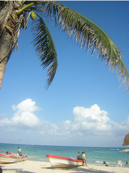
Tanzania is located on the Indian Ocean. In fact, the entire eastern side of Tanzania’s mainland is coastal, and Zanzibar and Pemba are both islands in the Indian Ocean just off of the Tanzanian mainland. Dar es Salaam, Tanzania’s largest city and business center, is located right on the Indian Ocean coast and has a large port that serves as a hub for trade throughout East Africa, the Middle East, and South Asia. In fact, it is this location on the coast that has made Dar es Salaam such an important city. Indeed, Tanzania’s location on the Indian Ocean has had a big impact on its historical development. From the 11th century the Tanzanian coast was an important trading region. Arab traders from the Middle East settled along the coast and the interaction between inland Africans and coastal Arabs had a significant impact on the culture and economic development of the region. The Kiswahili language is an example of interaction of African, Arab, and South Asian cultures. While the grammar and structure of the language is very similar to other indigenous African languages belonging to the Niger-Congo language family, much of its vocabulary comes from Arabic. Currently, Dar es Salaam and other coastal cities as well as Zanzibar and Pemba are popular tourist destinations known for white sandy beaches, a tropical climate, and the beautiful blue-green water of the Indian Ocean.
As a tourist from another country and/or continent, what types of evidence would you look for to help you piece together Tanzania’s story based on its position on the Indian Ocean?
Mountains and Craters
Mount Kilimanjaro

Mount Kilimanjaro is the highest peak in Africa and one of the most famous mountains in the world. The mountain is located in northern Tanzania, near the city of Moshi, and is composed of three extinct or dormant volcanoes. It is a major tourist destination for people from around the world, and these visitors significantly support Tanzania’s tourism industry. Every year approximately 15,000 people attempt to climb Kilimanjaro and about 40% of those people actually reach the summit. There are three routes up the mountain that are fairly accessible to non-expert climbers. They require no mountaineering experience, only that the climber be in good health. On the way up the mountain, climbers can experience almost every climate type on earth because of Kilimanjaro’s proximity to the equator and its high elevation.
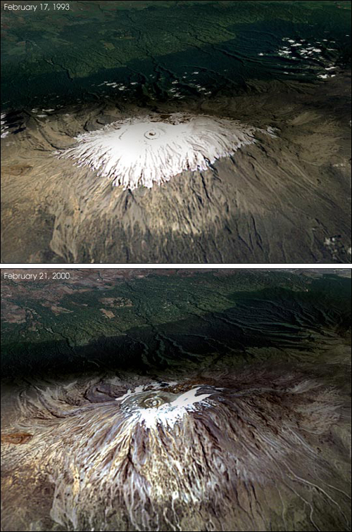
Kilimanjaro is actually a volcano or, more accurately, it is made up of three extinct volcanoes. The mountain has two peaks—the Uhuru (“freedom” in Kiswahili) peak, which is located on the Kibo rise, and the Mawenzi peak. The Uhuru peak is the tallest, measuring 5895 meters or 19,340 feet above sea level. The Mawenzi peak is 5149 meters or 16,892 feet above sea level. The crater on the Uhuru peak is covered by an ice cap year round, however, over the past century the ice cap has been rapidly shrinking. One study indicates that it has dropped in volume by as much as 80% during this time. Many experts attribute this phenomenon to global warming. This could have a serious effect on the surrounding communities who rely on the ice cap for water in the dry season and for the Chagga (the region’s majority ethnic group) farmers, who grow coffee and plantains on the mountain’s lower slopes. The melting ice caps may also affect the tourist industry on the mountain. There have been more frequent rock slides at the top of the mountain as the glaciers melt and the underlying rocks begin to shift. This could make future treks up the mountain increasingly unpredictable and unsafe.
Imagine your family lives near Mt. Kilimanjaro. Potentially, how is your family helped by the famous mountain? What are the potential challenges associated with living near this site?
Activity: Imagine you own a local tourist company and you are promoting trips to Mt. Kilimanjaro. Prepare a description and an exciting page in a brochure to entice people to this site.
Mount Meru
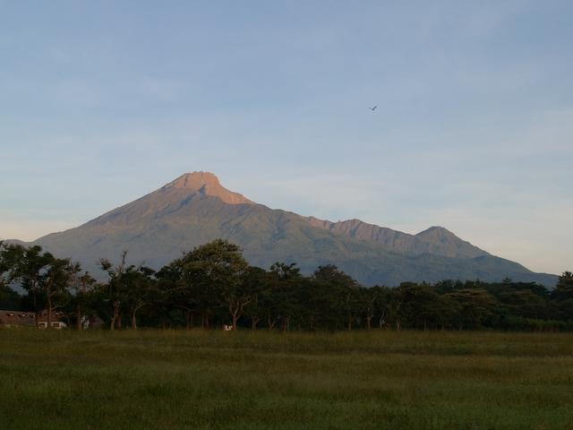
Mount Meru is located not far from Mount Kilimanjaro (about 70 km or 44 miles to the west) in northern Tanzania in Arusha National Park near the city of Arusha. It is an active volcano whose last known eruption was in 1910. It has several cones and craters that probably are the result of several past eruptions. A volcanic blast about 8,000 years ago caused the mountain to lose much of its previous height. Today the mountain is 4,566 meters (or 14,980 feet)
Olduvai Gorge

Olduvai Gorge (or Olupai as it is known in the local Maasai language), named after a plant that grows profusely in the surrounding area, is located in the eastern Serengeti plains of northern Tanzania. It is an archaeological site that has yielded artifacts and fossils that range from 2,100,000 to 15,000 years ago. Olduvai is sometimes referred to as “The Cradle of Humankind” because fossils found here are some of the earliest evidence that we have of prehistoric human evolution. The earliest deposits of artifacts includes evidence of campfires, stone tools and bones of our human ancestors (including Homo habilis).
Activity: Envision yourself leading a tour through Olduvai Gorge. You are driving a rover through this area. Prepare your verbal presentation to a dozen teenagers from America. What would you say to them?
Ngorongoro Crater
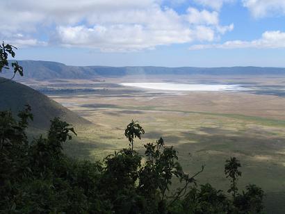
Ngorongoro Crater is located near the Serengeti plains in northern Tanzania, just to the east of Olduvai Gorge. It is the largest unbroken caldera in the world. (A caldera is a volcanic feature formed by the collapse of a volcano into itself causing a crater. The name comes from the Spanish word ‘caldera’ which means ‘cauldron’.) The crater itself is 610 meters deep (2,002 feet), its floor has a surface area of 260 square kilometers (161.5 square miles). A large variety of wildlife live within the crater, including zebra, wildebeest, lions, cheetahs, water buffalo, elephants, gazelles, leopards, rhinoceros and numerous species of birds. It is known as one of the best places to see the black rhinoceros, which is currently endangered, and the lake on the crater floor is home to a large variety of birds. Ngorongoro is one of Tanzania’s most popular tourist destinations for game watching and safaris.
Important Economic Activities

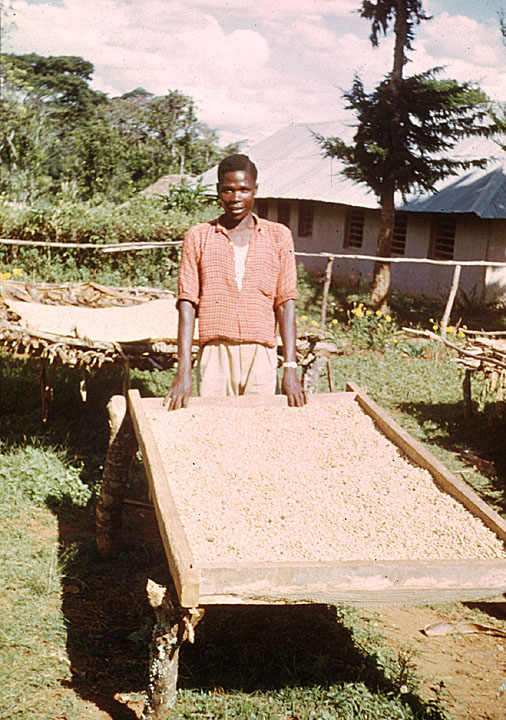
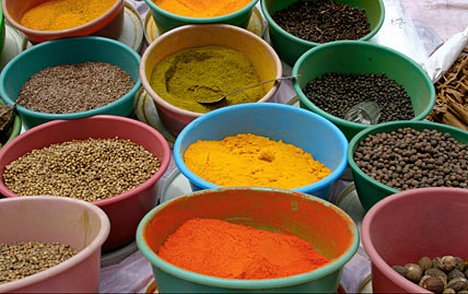
The most important economic activity by far in Tanzania is agriculture. This industry accounts for almost half of the country’s GDP (Gross Domestic Product), 85% of its exports, and employs 80% of its labor force. The major cash or commercial crops that are grown throughout the country include coffee, sisal, tea, cotton, pyrethrum (insecticide made from chrysanthemums), cashew nuts, tobacco, and cloves. Maize (corn), wheat, cassava (tapioca), bananas, and other fruits and vegetables are the primary foods cultivated in the country. The island of Zanzibar is especially known for producing spices, like cloves, nutmeg, cinnamon and pepper. Tanzanians also raise cattle, sheep and goats. As mentioned above, the climate and the topography of the various regions determine what type of crops are grown and what types of animals are raised in a given area.
The fishing industry is another important part of Tanzania’s economy, as noted earlier, due to Tanzania’s position on the Indian Ocean and the Great Lakes (Victoria, Tangayika and Malawi) that make up much of its borders.
The mining industry also contributes to Tanzania’s economy. The industry is of growing in importance. In recent years there has been significant international investment in mines which has led to the increased production of gold and other minerals and gems. Of course, this increase in mining activity has an environmental impact on the country and many are concerned that it could affect Tanzania’s picturesque landscape and its tourist industry. Products that come from Tanzanian mines include gold, diamonds, tanzanite—a gem that is only found in Tanzania, coal, tin, uranium, iron, nickel, salt and limestone.

Tourism, as mentioned previously, is very important to Tanzania’s economy. You may have heard of the Serengeti plains where giraffe, elephants, lions, and wildebeest roam freely. This area is actually a national wildlife reserve located in Tanzania. Indeed, many people travel from all over the world to come to this reserve on “safari” (which means “trip” in Kiswahili) as well as visit Tanzania’s other game parks and attractions. Among the other sites that attract tourists are those discussed throughout the lesson—Mount Kilimanjaro, Ngorongoro Crater, Olduvai Gorge, Zanzibar and Pemba.
Activity: Imagine that you will design a career related to farming, fishing, or mining. Which would you select and why? Design/describe your ideal career within one of these industries. We encourage you to engage in outside research. Create a detailed description of your successful career. What types of designs will you need to make to be successful and thereby bring economic success to Tanzania?
Language
Tanzania, like many countries in sub-Saharan Africa, is home to many languages. In total, the people of Tanzania speak approximately 120 different languages. Most people also speak English and Kiswahili. English was introduced to the region by British colonialists and Kiswahili was developed as a trade language on the coast and in Zanzibar and then spread to the interior of the country. Kiswahili is the official language of the country, which means that all government business is conducted in this language. Tanzania is one of the few sub-Saharan African countries to use an indigenous African language as an official language. Kiswahili, which is the most widely spoken African language in the entire continent, also serves as a regional lingua franca, because there are speakers of this language in Kenya, Uganda, eastern Congo, Burundi, and Rwanda.
If you were to learn a new language as a Tanzanian, what would it be and why?
Do you think it is a good idea to have an indigenous language as the official language? What are the trade-offs?
People
According to the evidence uncovered at Olduvai Gorge, the history of human habitation in Tanzania dates back nearly two and a half million years. Throughout the course of the region’s history several groups of people have migrated into Tanzania and several settled in the region. The next lesson will examine who these groups are and how they came to live in the region. Today, of the more than 40 million people living in Tanzania, there are over 120 different ethnic groups, none of whom makes up more than 13 percent of the population. This means that Tanzania is truly multiethnic and no one group dominants the country politically. Some of the larger ethnic groups include the Sukuma, the Haya, the Nyakyusa, the Nyamwezi and the Chagga. There are also a few nomadic groups that live in Tanzania including the Maasai who many Europeans and Americans most associate with East Africa because of their distinctive dress and culture. Often when you see postcards or books that depict Tanzania, you will see tall people draped in red blankets, ornamented with beaded jewelry, and carrying thin walking sticks. These are the Maasai and while they are among the most easily recognizable East Africans, they are only one of Tanzania’s many ethnic groups. The majority of Tanzania’s population is African, however a number of South Asians (mostly from India) and Europeans reside there as well.
What are the potential advantages and disadvantages of living in a multi ethnic society?
Do you think that the depictions of groups like the Maasai in popular culture contribute to the tourist industry of Tanzania? Why or why not?
Tanzania is also religiously diverse. Just under half of the population practices Christianity and approximately 35 percent of the population are Muslims. Some Tanzanians continue to follow traditional belief systems. A small proportion of the population practices religions from South Asia such as Hinduism and Sikhism. The populations of Zanzibar and Pemba are predominantly Muslim.
When compared with other developing countries, Tanzania has a fairly high literacy rate. It is currently estimated that about 79 percent of people over 15 years old can read and write in English, Kiswahili, or Arabic. Tanzania is also working toward universal primary and secondary education. As of 2007 approximately 97 percent of children were enrolled in primary school and around 20% of young adults aged 15-24 were attending secondary school.
If you were a member of a national commission for education in Tanzania, what would you include on your agenda for K-12 schools? Why? How do you think the face of Tanzania will change as more and more students complete secondary school and university?
Go on to Activity Two or choose from one of the other activities in this module.
- Introduction
- Activity One: Introducing Tanzania
- Activity Two: The History of Tanzania
- Activity Three: Tourism, the Economy, and Development in Tanzania
- Activity Four: Tanzania in the Indian Ocean World